Select your language




Case studies
Hydraulic Monitoring of Irrigation Canals
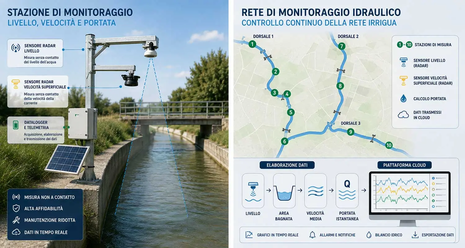
Tecnopenta designed and implemented a hydraulic monitoring system distributed across an open-channel irrigation network, with the aim of verifying operating conditions, assessing the actual flow rates and monitoring the main hydraulically critical points.
The project involved three irrigation branches characterized by different geometries, concrete-lined sections, prefabricated channels, crossings, constrictions, diversions and bed drops. The network also has a strongly seasonal operating regime, with minimum flow rates during winter and maximum values during the irrigation season.
Hydraulic analysis and identification of measurement points
The system design started from the analysis of the hydraulic model of the network, which was used to identify the most sensitive sections and define the points that best represent the overall hydraulic behaviour of the canals.
Based on this analysis, ten monitoring points were identified, mainly located near diversions, bridges, crossings, section constrictions, significant flow variations and areas affected by backwater phenomena.
This approach made it possible to concentrate the instrumentation at the most significant locations, avoiding a uniform distribution of sensors throughout the network.
Radar measurement of water level and velocity
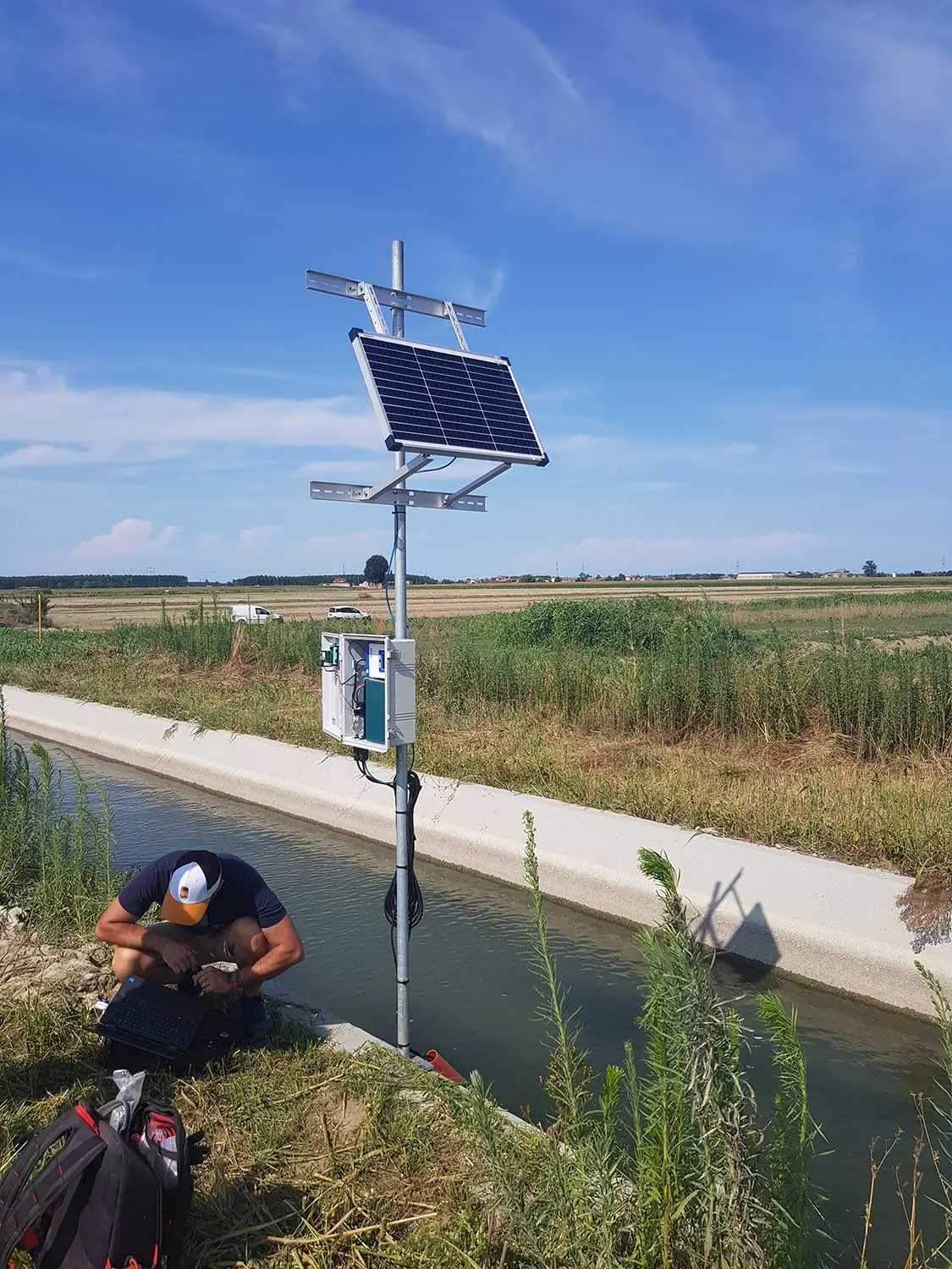
Water level measurement is carried out using non-contact radar sensors installed above the free water surface of the canal.
This technology avoids direct contact with the water, reducing issues related to sediment, vegetation, material transported by the current and maintenance of submerged components.
At the main stations, water level measurement is combined with a radar sensor for surface water velocity, also installed above the water.
Continuous flow calculation
The combination of water level, cross-section geometry and flow velocity makes it possible to continuously determine the instantaneous flow rate passing through each measurement point.
The system also calculates the cumulative volume, making it possible to determine the total amount of water that has passed during a day, a week, an irrigation season or a selected time interval.
Comparing flow rates measured upstream and downstream of the main diversions makes it possible to progressively reconstruct the hydraulic balance of the network and assess the distribution of irrigation water.
Monitoring backwater phenomena
Simultaneous level monitoring in consecutive sections makes it possible to observe the development of backwater phenomena and identify abnormal changes in flow conditions.
This information can highlight conditions related to obstructions, material accumulation, vegetation, reduced conveyance capacity or anomalies in hydraulic structures along the canal.
Data acquisition and METRA platform
Each station is connected to an industrial data logger that manages sensor power supply, measurement acquisition, local processing, storage and remote data transmission.
Data are transmitted via the cellular network to Tecnopenta’s METRA platform, where they are stored and organized into time series.
For each station, graphs are available for water level, velocity, instantaneous flow rate, cumulative volume, battery status and system diagnostics.
Alarm thresholds and network control
Progressive thresholds associated with water level have been defined for the most hydraulically sensitive points.
When the preset values are exceeded, the system can quickly identify abnormal conditions such as rising water levels, formation of backwater effects, reduced conveyance capacity, flow rates above expected values or sudden absence of flow.
Alarms are displayed on the platform and can be automatically transmitted to the operators responsible for managing the network.
From hydraulic modelling to digital monitoring
One of the most significant aspects of the project is the integration of hydraulic modelling, physical infrastructure and real measurements.
The combined use of non-contact radar sensors, telemetry and digital platforms makes it possible to transform a traditional irrigation network into an infrastructure that can be monitored over time.
The collected data make it possible to verify distribution efficiency, identify anomalies, analyse water balances and provide a quantitative basis for the management and maintenance of the irrigation network.