Select your language




Case studies
Structural Monitoring of Bridges
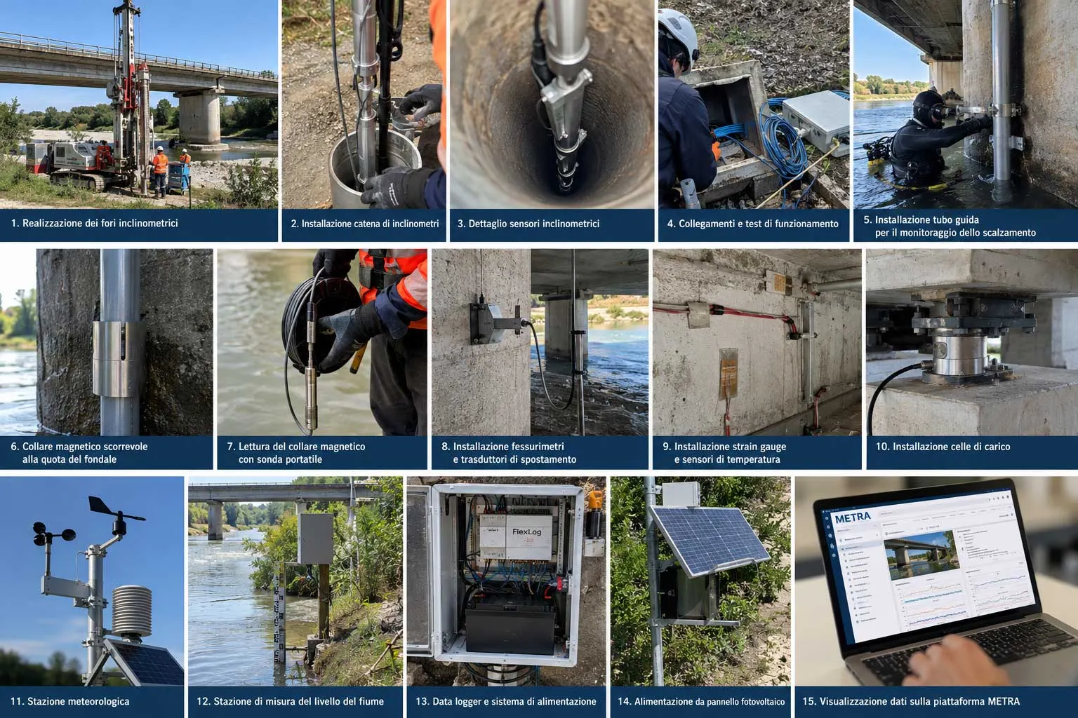
Structural monitoring of bridges cannot be limited to the structure alone. When a bridge crosses a watercourse and its foundations interact with the ground and river dynamics, it is important to consider the behaviour of the subsoil, foundations, piers and deck, together with the environmental and hydraulic conditions that may influence their response.
This case study presents an integrated geotechnical and structural monitoring system for a bridge, with automatic data acquisition and centralization of information on the METRA platform.
The aim is to obtain an overall view of the behaviour of the structure by relating deep ground movements to displacements and structural deformations, as well as to changes in meteorological and hydraulic conditions.
Geotechnical monitoring of foundations
The first part of the system is dedicated to foundation monitoring and the control of deep ground movements near the bridge foundations.
Vertical boreholes are equipped with chains of fixed borehole inclinometers, consisting of digital sensors positioned at different depths. The distribution of the instruments along the vertical profile is defined according to the geotechnical characteristics of the site and the areas where monitoring the evolution of displacement is considered most significant.
Compared with traditional manual inclinometer surveys, the use of fixed inclinometers allows measurements to be acquired automatically and their evolution to be followed over time, making it possible to identify changes concentrated at specific depths.
The sensors are connected via a digital bus to acquisition units installed at the surface, allowing a large number of measurement points to be managed while limiting the amount of cabling required.
New inclinometer boreholes can also include elements for deep extensometric measurements. The combination of inclinometric measurements and extensometric measurements provides complementary information on horizontal displacements and vertical ground deformations affecting the foundations.
Structural monitoring of the bridge
The geotechnical system is integrated with a network of structural monitoring sensors installed directly on the bridge structure.
High-resolution inclinometers and tiltmeters can be installed on the bridge piers and main structural elements to monitor changes in inclination and rotation over time.
Electrical crack meters are installed across significant cracks to automatically measure variations in crack opening. Continuous crack monitoring makes it possible to distinguish stable or cyclic behaviour from progressive changes.
Wire displacement transducers can also be used to monitor relative displacement between structural elements, particularly when larger movement ranges are expected than those normally measurable with a crack meter.
Measurement of deformation and loads
Strain gauges can be installed on the most significant structural elements to measure local structural deformation.
Deformation measurements make it possible to monitor the response of structural elements over time to changes in loads and environmental conditions. For correct interpretation of the data, strain gauges are combined with temperature sensors so that measured deformation can be compared with thermal variations in the structure.
Temperature is one of the key parameters in the long-term monitoring of bridges and viaducts, since normal daily and seasonal temperature variations can cause significant changes in deformation and displacement.
Load cells can also be installed at selected points to directly monitor the evolution of forces transmitted through specific structural elements or restraint systems.
Bridge pier scour monitoring
For bridges whose foundations are directly affected by the current, an especially important parameter is the local erosion of the riverbed around the piers.
During flood events, increased flow velocity can remove material around the foundation, causing significant bridge pier scour.
A passive magnetic system can be used for scour monitoring, preserving a physical record of the maximum erosion depth reached during the event.
The device consists of a vertical guide tube installed near the pier and a sliding magnetic collar initially positioned at riverbed level. During a flood, erosion causes the collar to progressively move downward along the tube.
When material is subsequently redeposited, the collar remains at the maximum depth reached. After the event, its position can be detected using a magnetometric probe connected to a graduated cable, allowing the maximum scour depth to be determined.
The system is completely passive and requires neither electrical power nor connection to a data logger.
Monitoring the watercourse level
The system also includes a station for the continuous measurement of water level in the watercourse.
River level monitoring makes it possible to identify and characterize flood events and to relate hydraulic conditions to variations recorded by the geotechnical and structural instrumentation.
The water level trend also provides an important reference for planning inspections of passive scour monitoring systems after the most significant events.
Meteorological monitoring
The environmental monitoring framework is completed by an automatic weather station.
The station records precipitation, air temperature and humidity, atmospheric pressure, wind speed and wind direction.
Comparing precipitation, water level and instrumentation response makes it possible to reconstruct the evolution of the most significant events and assess possible correlations between environmental conditions and structural behaviour.
Data acquisition and transmission
The automatic instrumentation is connected to distributed data loggers installed near the different measurement groups.
The acquisition units handle sensor interrogation, local storage of measurements and remote data transmission.
Where electrical power is unavailable, the stations can be powered by batteries and photovoltaic panels, allowing autonomous systems to be installed even in difficult-to-access areas.
METRA platform for data management
Data from the different stations are centralized on the METRA cloud platform, which provides a single access point to the monitoring system.
METRA stores the acquired measurements and displays their evolution through time-series graphs and representations organized by site, position and sensor type.
One of the main advantages of an integrated monitoring system is the possibility of comparing different types of parameters over the same time interval.
Precipitation can be related to the watercourse level and to deep ground movements detected by inclinometers. These can in turn be compared with pier rotations, crack opening and displacements measured on the structure.
Similarly, temperature, deformation measured by strain gauges and displacement can be analysed together to identify cyclic structural behaviour associated with temperature variations and detect changes requiring further investigation.
The platform also allows attention, warning and alarm thresholds to be associated with monitored parameters. Exceeding these thresholds can generate automatic alerts, allowing technicians to focus quickly on the most significant variations.
An integrated bridge monitoring system
The value of a structural and geotechnical bridge monitoring system does not depend simply on the number of sensors installed, but on the ability to relate information from different phenomena.
A change in watercourse level can be compared with deep ground movements, which can in turn be related to pier rotations and to structural displacements or deformations.
Bridge pier scour monitoring adds particularly important information by preserving evidence of the maximum erosion reached during a flood, even when subsequent sediment deposition makes the phenomenon difficult to identify through a later inspection.
The integration of geotechnical monitoring, structural monitoring, hydraulic monitoring and meteorological monitoring, together with data centralization on the METRA platform, makes it possible to move from measuring individual parameters to an overall interpretation of the behaviour of the bridge over time.