Select your language




Case studies
Flow Monitoring with Radar Technology
Continuous flow measurement in a river or channel can become particularly complex when site conditions make the installation of instruments directly in contact with the water impractical.
High currents, rapid water level variations, sediment transport and floating debris can increase maintenance requirements and the risk of damage to submerged sensors.
In this case study, an automatic monitoring station for a watercourse using non-contact radar technology is considered. The solution combines surface water velocity measurement with water level monitoring and a remote data acquisition and transmission system.
The aim is to achieve continuous monitoring of the watercourse, with particular attention to flood events, while keeping the measuring instrumentation outside the flow.
Measuring water velocity without contact
Surface velocity is measured using a Doppler radar sensor. The instrument transmits an electromagnetic signal towards the water surface and analyses the frequency shift of the signal reflected by the moving surface.
This variation makes it possible to determine the water velocity without contact, avoiding the need to install the sensor directly in the water.
In this type of configuration, a radar operating in the 24 GHz band can be used, capable of detecting surface velocities approximately between 0.02 and 15 m/s.
The system can therefore be used both under normal flow conditions and during events characterized by significantly higher velocities.
The sensor can also integrate inclination measurement, allowing the effect of the installation angle on the measured velocity to be automatically compensated.
Installing the radar above the watercourse
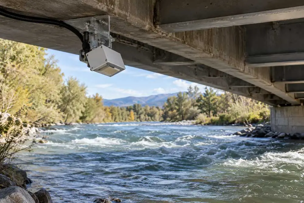
In the considered configuration, the radar sensor is installed beneath a bridge deck and oriented towards a portion of the water surface that is sufficiently representative of the flow.
A typical configuration may involve positioning the radar approximately 1 to 25 metres above the water surface, with an inclination of about 30°.
The possibility of performing a completely non-contact measurement is one of the main advantages of this technology. With no measuring elements submerged in the water, the sensor is less exposed to branches, vegetation, sediment and floating debris transported during floods.
This aspect is particularly useful for streams and watercourses characterized by rapid changes in hydraulic conditions, where the risk of damage to instrumentation installed in the channel increases precisely during the most important events to be monitored.
From surface velocity to flow rate
Radar measurement directly provides the surface water velocity. In many hydrological monitoring applications, however, the most significant parameter is the flow rate, normally expressed in cubic metres per second.
In general terms, flow rate can be determined using the relationship:
Q = V × A
where Q is the flow rate, V is the mean water velocity and A is the wetted cross-sectional area.
In a real watercourse, however, the calculation is more complex because the cross-section may be irregular and water velocity is not uniform either across the width or along the vertical profile.
The surface velocity measured by the radar therefore does not necessarily correspond to the mean velocity of the entire cross-section.
As a general reference, mean velocity may range approximately between 80% and 95% of surface velocity, but the coefficient to be used must be evaluated according to the characteristics of the specific site.
To obtain reliable results, it is therefore advisable to carry out an initial characterization of the hydraulic section and compare radar measurements with direct flow measurements performed under different flow conditions.
The importance of water level measurement
To create a complete station, radar velocity measurement can be combined with a sensor for continuous water level measurement.
Knowing the water level is essential because it makes it possible to determine how the wetted cross-section changes as the water depth varies.
By combining this information with the surface velocity measured by radar, it is possible to reconstruct the flow rate trend over time.
The station can therefore simultaneously observe the rise in water level and the increase in flow velocity during a meteorological event.
Once the hydraulic behaviour of the section has been characterized, the acquired data can be automatically processed to obtain a continuous flow rate estimate.
Automatic data acquisition
The velocity radar can be connected directly to a data logger through an RS-485 digital interface and Modbus protocol.
The acquisition system can then periodically query the sensor and record the measured velocity values.
The same data logger can also acquire the level sensor and any other instruments installed at the station, centralizing all information in a single system.
It is also possible to acquire both instantaneous velocity and a suitably filtered average velocity. In the presence of waves or small surface oscillations, using an averaged value reduces measurement fluctuations and provides a value that is more representative of the actual watercourse conditions.
Data transmission and METRA platform
Locally recorded data can be transmitted via mobile network to the METRA platform, enabling remote monitoring of the station.
The operator can therefore view the time trend of water level, surface velocity and calculated flow rate, monitoring the evolution of the watercourse without having to physically reach the site.
The simultaneous availability of different parameters also allows hydrological events to be interpreted more completely and conditions recorded during different events to be compared.
Monitoring flood events
One of the most interesting aspects of this configuration becomes apparent during flood events.
With the arrival of rainfall, the system can initially record the increase in water level and subsequently the variation in flow velocity.
By combining this information with the cross-section geometry, it is possible to follow the evolution of the flow rate up to the maximum value and throughout the subsequent decreasing phase.
The entire event is recorded automatically, creating a historical data series that can subsequently be analysed and compared with previous events.
The accumulation of data over time also makes it possible to progressively improve knowledge of the hydraulic behaviour of the site and, when necessary, refine the relationships used to convert water level and surface velocity into flow rate.
A solution for rivers, streams and channels
Non-contact radar measurement is particularly suitable for monitoring rivers, streams and open channels where installing submerged instruments is complex or requires frequent maintenance.
Bridges and crossings are particularly suitable locations for this type of application because they allow the sensors to be installed directly above the watercourse without building structures inside the channel.
The integration of velocity radar, water level measurement, data logger and remote transmission makes it possible to create an automatic station capable of continuously monitoring the evolution of hydraulic conditions.
The result is not simply a measurement of water velocity, but a complete flow monitoring system that transforms field data into useful information for understanding watercourse behaviour and reconstructing even the most significant hydrological events.